Admiralty Scaffolding
Admiralty Scaffolding (84666)
- Easting
- 556398
- Northing
- 358032
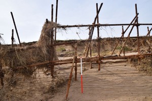
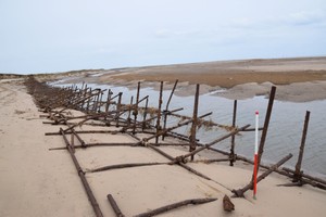
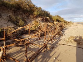
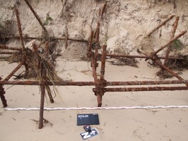
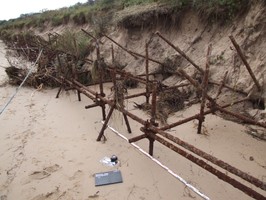
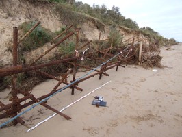
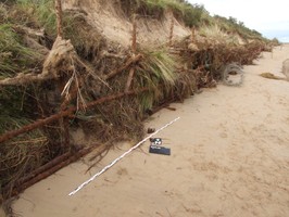
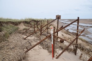
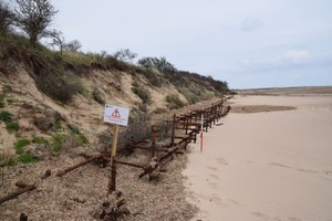
Field survey 25-03-24 - A Sherman and L Northall The scaffolding is exposed for a length of approximately 270m between NGR TF 56384 58015 and TF 56473 58272. At the northern end of the scaffolding the defenses are swallowed by the sands dune and it is possible that more scaffolding survives within the dunes north of the exposed area. The area of scaffolding at the southern end of the run has been heavily eroded and little survives now above the sand, with the southern end of the scaffolding having an average height of 0.4m. However, towards the north the scaffolding survives to a much greater height. A maximum depth of 3.13m and height of 1.47m was recorded for the feature at the northern end of the run. At it's highest point, towards the center of the exposure (approximately TF 56465 58203), the scaffolding had a surviving height of approximately 2.70m. To the rear of the scaffolding several dumps of Dannert wire and screw pickets were beginning to be exposed.
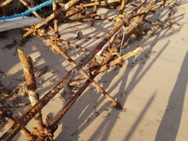
Field survey. 22 November 2021. C. Kolonko & H. Thompson- Extent Second World War Z1/2 Admiralty Scaffolding anti-tank obstacle exposed by erosion and shifting dune. The feature runs from South-West to North-East between grid references TF 56392 58024 and TF 56404 58036. The surviving scaffold remains relatively intact and complete to almost its original height. The feature also retains the sword pickets for anchoring the obstacle to the beach.
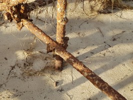
Record update and field survey. 6 November 2021. P. Hibbard- 3 meter scale used, 73 meters were exposed, constructed from 2" (50mm) cast iron scaffolding poles, horizontal poles were 20' (6.18) lengths, photo 1 is at TF56415 58076 what3words= reckoned/develop/curated.
- Period
- Modern (1901 and later)
- Period comments
Second World War (World War Two)- generally constructed from December 1940 onwards.
- The earliest date of the feature, as a year, if known
- 1940
- The latest date of the feature, as a year, if known
- 1943
- Monument Type - Broad
- ANTI TANK OBSTACLE|BEACH DEFENCE
- Monument Type - Narrow
- Monument Description
- Evidence Type - Broad
- Evidence Type - Narrow
- Evidence Description
- Object Type - Broad
- Object Type - Narrow
- Object Description
- Height OD (m)
- How accessible is the feature?
- Accessible on foot (no footpath)
- Accessibility comments
Other records:
- NRHE Number
- Unknown
- NT HBSMR Number
- Unknown
- HER Event Number
- Unknown
- External Link
- None
Over to you...
If you know there are errors in the original feature record above, you can edit the original record
If you would like to visit the feature and carry out a 'Feature Update Survey', you can prepare a 'Feature Update Survey' pack for this feature (in PDF format)
If you have completed a 'Feature Update Survey' for this feature, you can submit your 'Feature Update Survey'
If you want to use your smart phone to carry out the 'Feature Update Survey', you can download the CITiZAN smart app.
Feature Update Surveys
3 surveys accepted and 0 pending.
Click on a survey to expand it.
- Date of survey
- 6th November, 2021
- Feature located?
- State of the tide
- Proximity to coast edge
- Coastal processes
- Is there a coastal defence?
- Other threats?
- Structural damage/decay
- If other, please specify
- How visible are the remains? ABOVE GROUND
- How visible are the remains in the face of the cliff, ridge or dune? IN SECTION
- Do you know if the feature is?
- What actions (if any) would you recommend for this feature?
- Do you have any other comments?
- Date of survey
- 22nd November, 2021
- Feature located?
- State of the tide
- Low
- Proximity to coast edge
- Coastal processes
- Is there a coastal defence?
- No
- Other threats?
- Vegetation growth, Visitor erosion, Structural damage/decay
- If other, please specify
- How visible are the remains? ABOVE GROUND
- How visible are the remains in the face of the cliff, ridge or dune? IN SECTION
- Do you know if the feature is?
- What actions (if any) would you recommend for this feature?
- Do you have any other comments?
- Date of survey
- 26th March, 2024
- Feature located?
- State of the tide
- Low
- Proximity to coast edge
- Coastal processes
- Is there a coastal defence?
- No
- Other threats?
- Structural damage/decay, Water erosion (e.g. stream, etc)
- If other, please specify
- How visible are the remains? ABOVE GROUND
- How visible are the remains in the face of the cliff, ridge or dune? IN SECTION
- Do you know if the feature is?
- What actions (if any) would you recommend for this feature?
- Do you have any other comments?
Photos
Admiralty Scaffold by ChrisKolonko
Admiralty Scaffold by ChrisKolonko
Admiralty Scaffold by ChrisKolonko
Admiralty Scaffold by ChrisKolonko
Admiralty Scaffold by ChrisKolonko
Admiralty Scaffold by ChrisKolonko
Admiralty Scaffold by ChrisKolonko
Admiralty Scaffold by ChrisKolonko
Northern end of Z1 scaffolding by ASherman
Southern end of scaffolding by ASherman