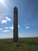
Rampside Navigation Tower
Rampside Navigation Tower (82673)
- Easting
- 324136
- Northing
- 466251
Approx 20m tall square brick-built navigation tower around1875. Grade 2 listed.
- Period
- Post-Medieval (1540 - 1901)
- Period comments
Built 1875
- The earliest date of the feature, as a year, if known
- 1875
- The latest date of the feature, as a year, if known
- 1875
- Monument Type - Broad
- Navigation aid
- Monument Type - Narrow
- Coast light
- Monument Description
- A beacon used for coastal navigation. Many date from the Medieval period.
- Evidence Type - Broad
- Structure
- Evidence Type - Narrow
- Extant
- Evidence Description
- Man-made roofless edifice or construction which is intact or substantially intact, with significant survival of original features, even if no longer serving original intended function.
- Object Type - Broad
- Object Type - Narrow
- Object Description
- Height OD (m)
- How accessible is the feature?
- Easily accessible - no restrictions
- Accessibility comments
Small banking from road down to Saltmarsh
Other records:
- NRHE Number
- 1197853
- NT HBSMR Number
- Unknown
- HER Event Number
- Unknown
- External Link
- None
Over to you...
If you know there are errors in the original feature record above, you can edit the original record
If you would like to visit the feature and carry out a 'Feature Update Survey', you can prepare a 'Feature Update Survey' pack for this feature (in PDF format)
If you have completed a 'Feature Update Survey' for this feature, you can submit your 'Feature Update Survey'
If you want to use your smart phone to carry out the 'Feature Update Survey', you can download the CITiZAN smart app.
Feature Update Surveys
1 survey accepted and 0 pending.
Click on a survey to expand it.
- Date of survey
- 16th July, 2017
- Feature located?
- Yes
- State of the tide
- Low
- Proximity to coast edge
- Coast edge
- Coastal processes
- Accreting
- Is there a coastal defence?
- Yes
- Other threats?
- Vegetation growth, Structural damage/decay
- If other, please specify
- How visible are the remains? ABOVE GROUND
- Highly visible (substantial remains)
- How visible are the remains in the face of the cliff, ridge or dune? IN SECTION
- Do you know if the feature is?
- Is well known, Has local associations/history
- What actions (if any) would you recommend for this feature?
Monitor structural decay
- Do you have any other comments?
Photos


