The 'Oyster Catcher's House'
The 'Oyster Catcher's House' (82073)
- Easting
- 468979
- Northing
- 103341
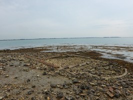
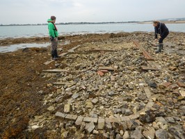
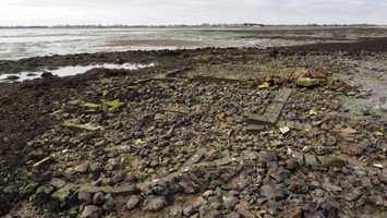
Remains of a building, wooden posts and a circular structure on Oyster Island in Langstone Harbour. Only the footings remain which are made up of brick and stone as well as some timber structures on the island edge. Believed to have been built in 1819 to guard the Oyster Beds. A historic photograph of the house can be found online - http://www.portsdown-tunnels.org.uk/surface_sites/qsite_p2.html
The site was last surveyed in the mid 1990’s as part of the Langstone Harbour Project. At the time the remains were interpreted as a WWI Observation Post and Searchlight base (Allen & Gardiner, 2000:107). However, further research suggests that the building foundations actually relate to the ‘Oyster Catchers House’, thought to have been built in 1819 by the Russel family as part of their oyster business. It is unclear whether the house was demolished in the 1950’s, or if it was destroyed in WWII as the area was used as a decoy site. Analysis of historic maps has also shown that the circular structure initially reported to be a WWI searchlight base is actually the remains of a well associated with the house. The site is known to be affected by erosion and changing sediment levels and was therefore selected as a monitoring site for the project.
- Period
- Post-Medieval (1540 - 1901)
- Period comments
- The earliest date of the feature, as a year, if known
- 1819
- The latest date of the feature, as a year, if known
- Monument Type - Broad
- Building
- Monument Type - Narrow
- Monument Description
- Evidence Type - Broad
- Building
- Evidence Type - Narrow
- Evidence Description
- Object Type - Broad
- Object Type - Narrow
- Object Description
- Height OD (m)
- How accessible is the feature?
- Not accessible, but visible from public path/road/adjacent land
- Accessibility comments
Permission required from the RSPB
Other records:
- NRHE Number
- Unknown
- NT HBSMR Number
- Unknown
- HER Event Number
- Unknown
- External Link
- None
Over to you...
If you know there are errors in the original feature record above, you can edit the original record
If you would like to visit the feature and carry out a 'Feature Update Survey', you can prepare a 'Feature Update Survey' pack for this feature (in PDF format)
If you have completed a 'Feature Update Survey' for this feature, you can submit your 'Feature Update Survey'
If you want to use your smart phone to carry out the 'Feature Update Survey', you can download the CITiZAN smart app.
Feature Update Surveys
3 surveys accepted and 0 pending.
Click on a survey to expand it.
- Date of survey
- 18th August, 2015
- Feature located?
- Yes
- State of the tide
- Mid
- Proximity to coast edge
- Coast edge
- Coastal processes
- Active sea erosion
- Is there a coastal defence?
- No
- Other threats?
- Structural damage/decay
- If other, please specify
- How visible are the remains? ABOVE GROUND
- Limited visibility (partial remains)
- How visible are the remains in the face of the cliff, ridge or dune? IN SECTION
- Do you know if the feature is?
- Has local associations/history
- What actions (if any) would you recommend for this feature?
- Do you have any other comments?
A historic photograph of the house can be found online - http://www.portsdown-tunnels.org.uk/surface_sites/qsite_p2.html
- Date of survey
- 10th January, 2017
- Feature located?
- Yes
- State of the tide
- Low
- Proximity to coast edge
- Coast edge
- Coastal processes
- Active sea erosion
- Is there a coastal defence?
- No
- Other threats?
- Structural damage/decay
- If other, please specify
- How visible are the remains? ABOVE GROUND
- Limited visibility (partial remains)
- How visible are the remains in the face of the cliff, ridge or dune? IN SECTION
- Do you know if the feature is?
- Has local associations/history
- What actions (if any) would you recommend for this feature?
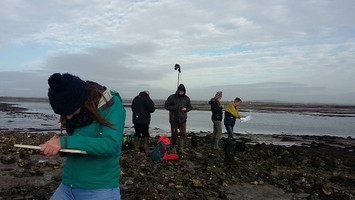
Continued monitoring of the remains, the area has been surveyed resulting in a site plan of the building and a 3D model, these can be used as a baseline for comparison over time.
- Do you have any other comments?
- Date of survey
- 30th November, 2017
- Feature located?
- State of the tide
- Proximity to coast edge
- Coastal processes
- Is there a coastal defence?
- Other threats?
- If other, please specify
- How visible are the remains? ABOVE GROUND
- How visible are the remains in the face of the cliff, ridge or dune? IN SECTION
- Do you know if the feature is?
- What actions (if any) would you recommend for this feature?
- Do you have any other comments?
Photos
Oyster Catchers House by LTidbury
Oyster Catchers House by LTidbury
Oystercatchers House by JasonK
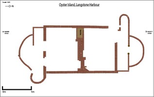
Site Plan of the building foundations by LTidbury