Ground marker
Ground marker (81972)
- Easting
- 644753
- Northing
- 248676
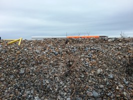
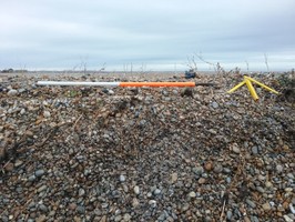
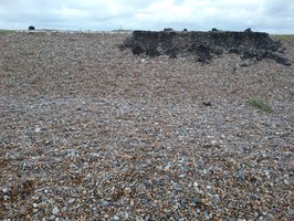
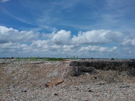
A square feature with two black squares and two white squares arranged in a chequerboard pattern. The black squares appear to be made of tar or pitch poured onto the shingle; the white squares are probably made of a lime slurry poured onto the shingle. The very straight edges suggested it was made in within shutters which were then removed. According to the exhibition in the Black Beacon and from information from the National Trust the ground marker was used in the calculation of position and height of aircraft during ballistics trials, and appears on aerial photograph from 1945 (on Google Earth).
Site visit September 2016: White section measurement E-W = 2.0m N-S = 4m Black section measurement E-W = c.3+m (the edges are ill defined as it spreads out) N-S = 4m
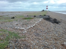
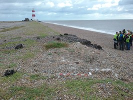
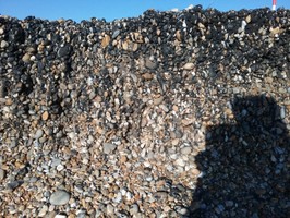
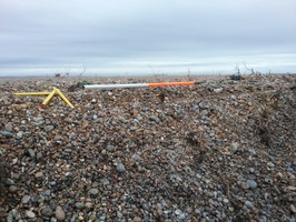
Site visit 20 January 2017: The two seaward squares have completely eroded away and only part of the northerly two squares still remain with the measurements as follows. Black section measurement E-W = 2.29m, N-S = 4.67m, 0.61m thick to full extent into shingle. White section E-W = 2.6m, N-S = 4.57m, 0.11m thick to full extent into shingle.
Site visit 3 June 3 2017 Marker further eroded Black section E-W = 2.20m, N-S = 4.67m White section E-W = 2.5m, N-S = 4.55m
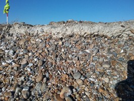
Site visit March 11 2018 Marker nearly totally erorded away. There is no evidence of the black section and the white section appears only as a c 8cm deep layer in the elevation created by the shingle shelf and is not visible in plan any longer.
- Period
- Modern (1901 and later)
- Period comments
The target can be seen on an aerial photograph taken in 1945 (Google Earth).
- The earliest date of the feature, as a year, if known
- 1945
- The latest date of the feature, as a year, if known
- Monument Type - Broad
- Military installation
- Monument Type - Narrow
- Monument Description
- Evidence Type - Broad
- Evidence Type - Narrow
- Evidence Description
- Object Type - Broad
- Object Type - Narrow
- Object Description
- Height OD (m)
- How accessible is the feature?
- Accessible - difficult terrain
- Accessibility comments
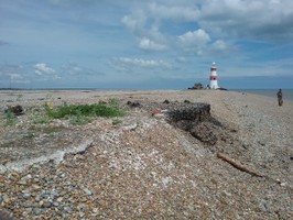
Access to Orford Ness is restricted and visitors must stick to the paths defined by the National
Trust, see https://www.nationaltrust.org.uk/orford-ness-national-nature-reserve. This feature has been recorded as part of CITiZAN recording weekends, with special access granted by the National Trust. This feature is visible from the beach, following the red route extension, but this may also be restricted at times.
Other records:
- NRHE Number
- Unknown
- NT HBSMR Number
- Unknown
- HER Event Number
- Unknown
- External Link
- None
Over to you...
If you know there are errors in the original feature record above, you can edit the original record
If you would like to visit the feature and carry out a 'Feature Update Survey', you can prepare a 'Feature Update Survey' pack for this feature (in PDF format)
If you have completed a 'Feature Update Survey' for this feature, you can submit your 'Feature Update Survey'
If you want to use your smart phone to carry out the 'Feature Update Survey', you can download the CITiZAN smart app.
Feature Update Surveys
4 surveys accepted and 0 pending.
Click on a survey to expand it.
- Date of survey
- 5th September, 2016
- Feature located?
- Yes
- State of the tide
- Low
- Proximity to coast edge
- Coast edge
- Coastal processes
- Active sea erosion
- Is there a coastal defence?
- No
- Other threats?
- If other, please specify
- How visible are the remains? ABOVE GROUND
- Highly visible (substantial remains)
- How visible are the remains in the face of the cliff, ridge or dune? IN SECTION
- Clearly visible in section
- Do you know if the feature is?
- Has local associations/history
- What actions (if any) would you recommend for this feature?
Coniyued monitoring. Historical research
- Do you have any other comments?
- Date of survey
- 20th January, 2017
- Feature located?
- Yes
- State of the tide
- Low
- Proximity to coast edge
- Coast edge
- Coastal processes
- Active sea erosion
- Is there a coastal defence?
- No
- Other threats?
- Vegetation growth
- If other, please specify
- How visible are the remains? ABOVE GROUND
- Highly visible (substantial remains)
- How visible are the remains in the face of the cliff, ridge or dune? IN SECTION
- Clearly visible in section
- Do you know if the feature is?
- Has local associations/history
- What actions (if any) would you recommend for this feature?
Continued monitoring. Testing of the white and black sections to define material.
- Do you have any other comments?
- Date of survey
- 20th June, 2017
- Feature located?
- Yes
- State of the tide
- Low
- Proximity to coast edge
- Coastal processes
- Active sea erosion
- Is there a coastal defence?
- No
- Other threats?
- If other, please specify
- How visible are the remains? ABOVE GROUND
- How visible are the remains in the face of the cliff, ridge or dune? IN SECTION
- Do you know if the feature is?
- Has local associations/history
- What actions (if any) would you recommend for this feature?
- Do you have any other comments?
- Date of survey
- 11th March, 2018
- Feature located?
- Yes
- State of the tide
- Low
- Proximity to coast edge
- Intertidal zone
- Coastal processes
- Active sea erosion, Has eroded in the past
- Is there a coastal defence?
- Other threats?
- If other, please specify
- How visible are the remains? ABOVE GROUND
- Limited visibility (partial remains)
- How visible are the remains in the face of the cliff, ridge or dune? IN SECTION
- Do you know if the feature is?
- What actions (if any) would you recommend for this feature?
- Do you have any other comments?
Photos
Target by LBand
Target by LBand
The target by LBand
The target by LBand
Ground marker by CITiZAN_SE_volunteers