Old Pier
Old Pier (81875)
- Easting
- 423689
- Northing
- 628525
A stone L-shaped structure, marked on a map from 1759 as an "Old Pier". It is located on the outer of the southern wall of the current Beadnell Harbour. The legs go on firstly on a south-west north- east alignment and the second leg on a west east alignment. The angle of the two legs are at a c.75 degree angle. Although marked on the 1759 map as an "Old Pier" only one leg is shown. The structure may have been used as a pier as a secondary use, thereally is the suggestion that the remains of the pier may originally have been used as fish trap, though there is little or no evidence of this. The pier had gone outo of use by 1759 as it is referred to as an "Old Pier" on the map. The pier is discuss in K. Portions book "Limekilns and Lobsterpots" 2013. Legacy System: LBS; UID: 408482 List Entry Number: 1233049; Grade: II; Date first listed: 26-Aug-1987
- Period
- Post-Medieval (1540 - 1901)
- Period comments
Pier pre-1759
- The earliest date of the feature, as a year, if known
- The latest date of the feature, as a year, if known
- Monument Type - Broad
- Landing point
- Monument Type - Narrow
- Jetty
- Monument Description
- A mole or pier-like structure situated at the entrance of a harbour, or running out into lake or the sea, so as to defend the harbour or coast.
- Evidence Type - Broad
- Structure
- Evidence Type - Narrow
- Ruined
- Evidence Description
- Man-made, roofless edifice or construction visible as substantial aboveground remains retaining evidence of architecture and materials, but which has been substantially destroyed.
- Object Type - Broad
- Object Type - Narrow
- Object Description
- Height OD (m)
- How accessible is the feature?
- Accessible - difficult terrain, Not accessible, but visible from public path/road/adjacent land
- Accessibility comments
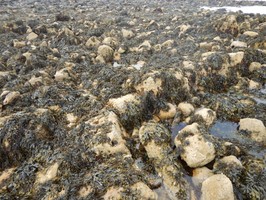
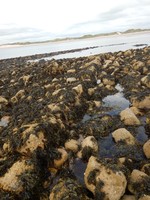
Can be seen from the current harbour. The foreshore is rocky and there is lots of seaweed so it is not easily accessible.
Other records:
- NRHE Number
- Unknown
- NT HBSMR Number
- Unknown
- HER Event Number
- Unknown
- External Link
- None
Over to you...
If you know there are errors in the original feature record above, you can edit the original record
If you would like to visit the feature and carry out a 'Feature Update Survey', you can prepare a 'Feature Update Survey' pack for this feature (in PDF format)
If you have completed a 'Feature Update Survey' for this feature, you can submit your 'Feature Update Survey'
If you want to use your smart phone to carry out the 'Feature Update Survey', you can download the CITiZAN smart app.
Feature Update Surveys
1 survey accepted and 0 pending.
Click on a survey to expand it.
- Date of survey
- 10th July, 2016
- Feature located?
- No
- State of the tide
- Low
- Proximity to coast edge
- Intertidal zone
- Coastal processes
- Active sea erosion, Has eroded in the past
- Is there a coastal defence?
- No
- Other threats?
- Vegetation growth, Structural damage/decay, Other
- If other, please specify
- Boats and other water transport/sports
- How visible are the remains? ABOVE GROUND
- Limited visibility (partial remains)
- How visible are the remains in the face of the cliff, ridge or dune? IN SECTION
- Not applicable
- Do you know if the feature is?
- Has local associations/history, Is not locally known
- What actions (if any) would you recommend for this feature?
- Do you have any other comments?