Anti-tank cylinders
Anti-tank cylinders (81749)
- Easting
- 633951
- Northing
- 162669
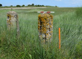
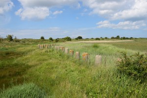
A line of c 300 concrete posts with rounded tops stretching for a least 200m. Curled iron hooks that would have held barbed wire are still extant in the tops of some of them.
JUNE 2020 No specific match to a Kent HER no. found, but assumed to be related to KENT HER no. MWX43195 https://webapps.kent.gov.uk/KCC.ExploringKentsPast.Web.Sites.Public/SingleResult.aspx?uid=MWX43195
Entry reads: "Large WWII military site comprising various typical military structures and defence features including gun emplacement pits, military buildings, several lengths of slit trenching and barbed wire located to the north of the entrance to the River Stour, Pegwell Bay and visible on military aerial photographs"
The cylinders are part of a Scheduled Ancient Monument along with a Type 24 pillbox and a line of anti-tank pimples to the north of the feature (List Entry no. 1413803: World War II anti-tank pimples and cylinders and associated pillbox at Pegwell Bay)
- Period
- Modern (1901 and later)
- Period comments
Part of the Second World War defences at Pegwell Bay Dating evidence from: Samuel, M & Hamlyn K. March 2013. Watching Brief on the WW2 Defences next to the Deal Road ((A256), Pegwell Bay, Ramsgate Historic England List Entry no. 1413803: World War II anti-tank pimples and cylinders and associated pillbox at Pegwell Bay
- The earliest date of the feature, as a year, if known
- 1939
- The latest date of the feature, as a year, if known
- 1940
- Monument Type - Broad
- Military coastal defences
- Monument Type - Narrow
- Monument Description
- Evidence Type - Broad
- Architectural component
- Evidence Type - Narrow
- Evidence Description
- Object Type - Broad
- Object Type - Narrow
- Object Description
- Height OD (m)
- How accessible is the feature?
- Accessible on foot (no footpath)
- Accessibility comments
The site lies within Stonelees Nature Reserve which is managed by Kent Wildlife Trust. The reserve is part of Sandwich and Pegwell Bay National Nature Reserve.
Other records:
- NRHE Number
- Unknown
- NT HBSMR Number
- Unknown
- HER Event Number
- Unknown
- External Link
- None
Over to you...
If you know there are errors in the original feature record above, you can edit the original record
If you would like to visit the feature and carry out a 'Feature Update Survey', you can prepare a 'Feature Update Survey' pack for this feature (in PDF format)
If you have completed a 'Feature Update Survey' for this feature, you can submit your 'Feature Update Survey'
If you want to use your smart phone to carry out the 'Feature Update Survey', you can download the CITiZAN smart app.
Feature Update Surveys
2 surveys accepted and 0 pending.
Click on a survey to expand it.
- Date of survey
- 26th June, 2016
- Feature located?
- Yes
- State of the tide
- Proximity to coast edge
- Coastal processes
- Accreting
- Is there a coastal defence?
- Other threats?
- Vegetation growth, Structural damage/decay, Other
- If other, please specify
- General weather conditions
- How visible are the remains? ABOVE GROUND
- Highly visible (substantial remains)
- How visible are the remains in the face of the cliff, ridge or dune? IN SECTION
- Do you know if the feature is?
- Is well known, Has local associations/history
- What actions (if any) would you recommend for this feature?
Continued monitoring
- Do you have any other comments?
- Date of survey
- 27th June, 2020
- Feature located?
- State of the tide
- Proximity to coast edge
- Coastal processes
- Is there a coastal defence?
- Other threats?
- If other, please specify
- How visible are the remains? ABOVE GROUND
- How visible are the remains in the face of the cliff, ridge or dune? IN SECTION
- Do you know if the feature is?
- What actions (if any) would you recommend for this feature?
- Do you have any other comments?
Photos
Anti tank cylinders by LBand
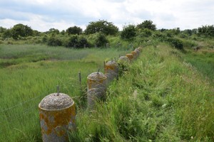
Anti tank cylinders by LBand
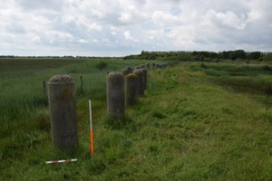
Anti tank cylinders- June 2016 by LBand