Southampton Water Defence Boom (Hook)
Southampton Water Defence Boom (Hook) (81734)
- Easting
- 450200
- Northing
- 103990
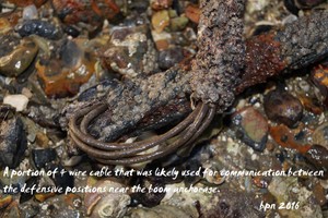
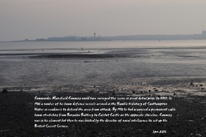
To enhance the defense of Southampton the Royal Navy installed a physical barrier called a boom which stretched across the mouth of Southampton Water. The boom was anchored at each end near Calshot Castle and Hook. This replaced a line of old hulks and ships .
There is a 3d model of the constructions at https://skfb.ly/68EHq
- Period
- Modern (1901 and later)
- Period comments
Defense barriers were in place at various periods in the early part of the 20th century starting with a row of ships & hulks. The cable boom was likely to have been constructed during 1909 though plans were drawn in 1907 (updated in 1911). The guns on the dolphins were decommissioned prior to WW1 due to failings in the design.
- The earliest date of the feature, as a year, if known
- The latest date of the feature, as a year, if known
- Monument Type - Broad
- Coastal defence site
- Monument Type - Narrow
- Monument Description
- Evidence Type - Broad
- Structure
- Evidence Type - Narrow
- Evidence Description
- Object Type - Broad
- Architectural fragment
- Object Type - Narrow
- Object Description
- Height OD (m)
- 0.00
- How accessible is the feature?
- Accessible - difficult terrain, Accessible on foot (no footpath)
- Accessibility comments
Other records:
- NRHE Number
- Unknown
- NT HBSMR Number
- Unknown
- HER Event Number
- Unknown
- External Link
- None
Over to you...
If you know there are errors in the original feature record above, you can edit the original record
If you would like to visit the feature and carry out a 'Feature Update Survey', you can prepare a 'Feature Update Survey' pack for this feature (in PDF format)
If you have completed a 'Feature Update Survey' for this feature, you can submit your 'Feature Update Survey'
If you want to use your smart phone to carry out the 'Feature Update Survey', you can download the CITiZAN smart app.
Feature Update Surveys
2 surveys accepted and 0 pending.
Click on a survey to expand it.
- Date of survey
- 12th March, 2016
- Feature located?
- Yes
- State of the tide
- Low
- Proximity to coast edge
- Intertidal zone
- Coastal processes
- Not eroding
- Is there a coastal defence?
- No
- Other threats?
- Vegetation growth, Structural damage/decay
- If other, please specify
- How visible are the remains? ABOVE GROUND
- Not visible
- How visible are the remains in the face of the cliff, ridge or dune? IN SECTION
- Limited visibility in section
- Do you know if the feature is?
- Don't know
- What actions (if any) would you recommend for this feature?
Possibly a measurement survey to create a plan.
- Do you have any other comments?
This record will be one of two or more records to cover both anchorages and between. There are already records for two QF guns mounted on wooden dolphins which also formed part of the defence at the entrance to Southampton Water.
- Date of survey
- 12th March, 2016
- Feature located?
- Yes
- State of the tide
- Low
- Proximity to coast edge
- Intertidal zone
- Coastal processes
- Active sea erosion, Has eroded in the past
- Is there a coastal defence?
- No
- Other threats?
- Vegetation growth, Water erosion (e.g. stream, etc)
- If other, please specify
- How visible are the remains? ABOVE GROUND
- Not visible
- How visible are the remains in the face of the cliff, ridge or dune? IN SECTION
- Limited visibility in section
- Do you know if the feature is?
- Is not locally known
- What actions (if any) would you recommend for this feature?
- Do you have any other comments?
Additional Photos from the original visit.
Photos
Bungalow Battery to Calshot Castle by fixerp

Timber piles by fixerp
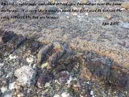
Cable Guide ? by fixerp