Middlebere Quay
Middlebere Quay (78293)
- Easting
- 397350
- Northing
- 86550
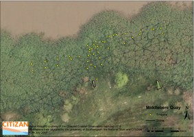
Remains of Middlebere Quay, Corfe Castle Estate. Towards the end of the 18th century clay pits were being dug at Norden to extract ball clay, in 1805 a tramway (technically known as a plateway - see http://www.citizan.org.uk/interactive-coastal-map/48746/) was built to transport the clay to barges moored at Middlebere Quay, which eventually fell out of use in 1905 as the clay began to be moved by train instead of barge. The quay was later used in WWII when the land was requisitioned by the war department.
The tramway ran for approximately 3 miles, the line of which can still be seen today along with several limestone blocks used to support the plates. It is though to be the earliest tramway in Dorset. An OS map from 1901 shows the extent of the quay as including two piers, a slipway, several buildings and a windlass.
The remains of the quay include a series of Purbeck limestone walls and a series of wooden piles protruding from the mudflats, ball clay can also be seen spread across the site. The site was re-visited by CITiZAN in July 2017 with help from the University of Southampton and National Trust volunteers and an RTK GPS system was used to plot the timbers, the site will be re-visited in the winter of 2017 to plot the remains of the tramway.
A study of the site was also carried out in 1982 by Martin Papworth as part of his dissertation and a survey of the site was drawn by B Langdown in 2007.
- Period
- Post-Medieval (1540 - 1901)
- Period comments
Early 19th C to Early 21st century
- The earliest date of the feature, as a year, if known
- 1806
- The latest date of the feature, as a year, if known
- 2050
- Monument Type - Broad
- QUAY|QUAY
- Monument Type - Narrow
- Monument Description
- Evidence Type - Broad
- Structure
- Evidence Type - Narrow
- Evidence Description
- Object Type - Broad
- Object Type - Narrow
- Object Description
- Height OD (m)
- 1.00
- How accessible is the feature?
- Accessible on foot (footpath)
- Accessibility comments
National Trust property, also the wooden remains are only accessible at low tide.
Other records:
- NRHE Number
- Unknown
- NT HBSMR Number
- MNA139055
- HER Event Number
- Unknown
- External Link
- None
Over to you...
If you know there are errors in the original feature record above, you can edit the original record
If you would like to visit the feature and carry out a 'Feature Update Survey', you can prepare a 'Feature Update Survey' pack for this feature (in PDF format)
If you have completed a 'Feature Update Survey' for this feature, you can submit your 'Feature Update Survey'
If you want to use your smart phone to carry out the 'Feature Update Survey', you can download the CITiZAN smart app.
Feature Update Surveys
1 survey accepted and 0 pending.
Click on a survey to expand it.
- Date of survey
- 12th July, 2017
- Feature located?
- Yes
- State of the tide
- Low
- Proximity to coast edge
- Intertidal zone
- Coastal processes
- Active sea erosion
- Is there a coastal defence?
- No
- Other threats?
- Vegetation growth, Structural damage/decay
- If other, please specify
- How visible are the remains? ABOVE GROUND
- Limited visibility (partial remains)
- How visible are the remains in the face of the cliff, ridge or dune? IN SECTION
- Do you know if the feature is?
- Is well known, Has local associations/history
- What actions (if any) would you recommend for this feature?
The site will be revisited in the winter of 2017 when there is less vegetation in order to plot the remains of the tramway as well as the quay
- Do you have any other comments?
Photos