Fort Henry, Studland
Fort Henry, Studland (78198)
- Easting
- 403787
- Northing
- 82839
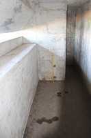
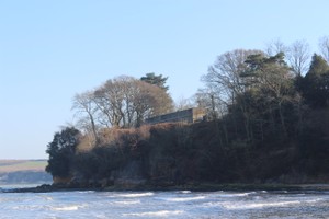
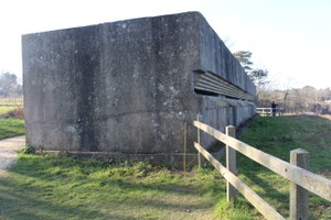
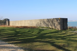
FORT HENRY is situated on the cliff edge, immediately in front of the gun emplacement. It a large rectangular structure of reinforced concrete and is orientated north-west to south-east. It measures 138m long and 3m wide and its walls are 1m thick. To the seaward (north-east) elevation is a recessed observation slit that runs the entire length of the structure. Entrances at either end provide access to the interior which takes the form of a long, narrow corridor with a staggered blast wall at approximately the halfway point.
https://historicengland.org.uk/listing/the-list/list-entry/1411809
- Period
- Post-Medieval (1540 - 1901), Modern (1901 and later)
- Period comments
By August 1940, a gun emplacement for a six-pounder gun had been constructed at Redend Point in Studland, part of the anti-invasion defences laid out around Studland Bay. Its line of fire was partly blocked by the construction in 1943 of FORT HENRY, a purpose-built observation post, immediately to the east. It was built by the Canadian Royal Engineers and was named after their home base in Ontario. In April 1944 King George VI, Winston Churchill, General Sir Bernard Montgomery, General Dwight D. Eisenhower and Acting Admiral Louis Mountbatten observed a demonstration of carpet bombing followed by assault landings, part of Exercise Smash 1, from Fort Henry.
https://historicengland.org.uk/listing/the-list/list-entry/1411809
- The earliest date of the feature, as a year, if known
- 1943
- The latest date of the feature, as a year, if known
- 1943
- Monument Type - Broad
- BLOCKHOUSE
- Monument Type - Narrow
- Monument Description
- Evidence Type - Broad
- Building
- Evidence Type - Narrow
- Evidence Description
- Object Type - Broad
- Object Type - Narrow
- Object Description
- Height OD (m)
- 15.00
- How accessible is the feature?
- Easily accessible - no restrictions, Accessible on foot (footpath)
- Accessibility comments
The monument is open to the public and has display and information boards
Other records:
- NRHE Number
- Unknown
- NT HBSMR Number
- MNA137818
- HER Event Number
- Unknown
- External Link
- None
Over to you...
If you know there are errors in the original feature record above, you can edit the original record
If you would like to visit the feature and carry out a 'Feature Update Survey', you can prepare a 'Feature Update Survey' pack for this feature (in PDF format)
If you have completed a 'Feature Update Survey' for this feature, you can submit your 'Feature Update Survey'
If you want to use your smart phone to carry out the 'Feature Update Survey', you can download the CITiZAN smart app.
Feature Update Surveys
1 survey accepted and 0 pending.
Click on a survey to expand it.
- Date of survey
- 26th February, 2018
- Feature located?
- Yes
- State of the tide
- Mid
- Proximity to coast edge
- Less than 10m inland
- Coastal processes
- Active sea erosion
- Is there a coastal defence?
- No
- Other threats?
- Visitor erosion, Structural damage/decay
- If other, please specify
- How visible are the remains? ABOVE GROUND
- Highly visible (substantial remains)
- How visible are the remains in the face of the cliff, ridge or dune? IN SECTION
- Do you know if the feature is?
- Is well known, Is well visited, Has local associations/history
- What actions (if any) would you recommend for this feature?
Occasional monitoring as structure is at risk of coastal erosion, over the next 100 years Shoreline Management plan SMP15 (Hurst Spit to Durlston Head) Local Authority Purbeck District Council
Type of defence Natural
20 year SMP management policy Managed realignment
Erosion predicted over 20 years Not applicable
50 year SMP management policy No active intervention
Erosion predicted over 50 years 25.4 - 38.8 metres
100 year SMP management policy No active intervention
Erosion predicted over 100 years 51.9 - 87.3 metres
*Based on a baseline of 2010- Do you have any other comments?
Photos
Fort Henry Overview by NickSwan
Fort Henry, front view from south end by NickSwan
Fort Henry - rear elevation by NickSwan