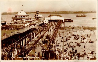
NEW BRIGHTON PIER
NEW BRIGHTON PIER (54016)
- Easting
- 331356
- Northing
- 394162
New Brighton Pier was designed and built between 1866 and 1867. The architect was Eugenious Birch and the builder was J. E Dowson. It may have replaced an earlier wooden pier. The pier was 600 feet in length and constructed of iron piles supporting four lines of longitudinal main girders and transverse wrought iron joists which carried timber decking. It provided a saloon, a central observation tower, cafes, shelters, a floating stage and an orchestra. It was repaired and modified between 1928 and 1930 and a pavilion was erected. The pier closed in 1865 but re-opened in 1968. Around £200,000 was spent on repairs and improvements before it again closed in 1972. It was demolished in 1977 after it was deemed unsafe.
Updated 02/10/19 by A Sherman: The first wooden pier at New Brighton was opened in 1834 and was said to be anchored to the bedrock with ropes. However, ships could not dock at the pier at low tide so a new metal pier, 600ft (182m) long was designed by Eugenius Birch and opened in 1867 ('The New Brighton Promenade Pier', Illustrated London News, 7th September 1867). Remains of the rock cut foundation holes for the pier are visible on the foreshore and some contain possible pile remains. The rock-cut foundation pits have a diameter of 1.40m, with at least 22 pits visible covering an area of approximately 3,000 square meters. See Citizan Id 83639 for record of possible pier pile. See Citizan Id 83642 for possible tethering ring.
- Period
- Post-Medieval (1540 - 1901), Modern (1901 and later)
- Period comments
repaired 1968|Possible use before 1866|demolished 1977|Built 1866-7|1928-1930 altered
- The earliest date of the feature, as a year, if known
- 1866|1968|1977|1928
- The latest date of the feature, as a year, if known
- 1866|1968|1977|1930
- Monument Type - Broad
- TOWER|BANDSTAND|PIER|SHELTER|TOILET|LANDING STAGE|BAR (LICENCED)|PLEASURE PIER|PIER PAVILION|CAFE
- Monument Type - Narrow
- Monument Description
- Evidence Type - Broad
- Destroyed monument
- Evidence Type - Narrow
- Evidence Description
- Object Type - Broad
- Object Type - Narrow
- Object Description
- Height OD (m)
- How accessible is the feature?
- Accessible - difficult terrain
- Accessibility comments
Other records:
- NRHE Number
- 67589
- NT HBSMR Number
- Unknown
- HER Event Number
- Unknown
- External Link
- None
Over to you...
If you know there are errors in the original feature record above, you can edit the original record
If you would like to visit the feature and carry out a 'Feature Update Survey', you can prepare a 'Feature Update Survey' pack for this feature (in PDF format)
If you have completed a 'Feature Update Survey' for this feature, you can submit your 'Feature Update Survey'
If you want to use your smart phone to carry out the 'Feature Update Survey', you can download the CITiZAN smart app.
Feature Update Surveys
2 surveys accepted and 0 pending.
Click on a survey to expand it.
- Date of survey
- 24th September, 2019
- Feature located?
- State of the tide
- Low
- Proximity to coast edge
- Coastal processes
- Is there a coastal defence?
- Yes
- Other threats?
- Vegetation growth
- If other, please specify
- How visible are the remains? ABOVE GROUND
- How visible are the remains in the face of the cliff, ridge or dune? IN SECTION
- Do you know if the feature is?
- What actions (if any) would you recommend for this feature?
- Do you have any other comments?
- Date of survey
- 27th September, 2019
- Feature located?
- State of the tide
- Low
- Proximity to coast edge
- Coastal processes
- Is there a coastal defence?
- Yes
- Other threats?
- Vegetation growth
- If other, please specify
- How visible are the remains? ABOVE GROUND
- How visible are the remains in the face of the cliff, ridge or dune? IN SECTION
- Do you know if the feature is?
- What actions (if any) would you recommend for this feature?
- Do you have any other comments?
Photos


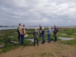
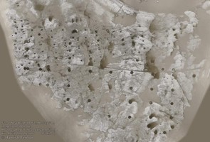
Image of 3d model created from aerial photograph of foreshore around New Brighton pier by North_Volunteer