PILLBOX
PILLBOX (26003)
- Easting
- 547292
- Northing
- 391678
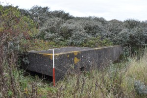
Second World War Type 23 'Lincolnshire-Type' pillbox East of Alberta in the Rimac Defended Locality.
Record update (29/11/2019) C. Kolonko-
Field survey undertaken on 10 October 2019 by C. Kolonko & S. Griffiths with C. Sanderson & L. & J. Havell (CITiZAN volunteers). With thanks to D. Suty of Natural England.
Second World War infantry pillbox built to bullet-proof standard. This pillbox design is often referred to as a 'Lincolnshire-Type' or 'Lincolnshire three-bay', though the origins of this term are unclear and it is not currently possible to confirm that this was a term used during the Second World War to describe this pillbox design. This pillbox design is also sometimes referred to as a 'FW3/23 variant'. Again, there has been no documentary research conducted to confirm whether this pillbox was considered a variant of the FW3/23 drawing at the time, or whether it was assigned its own specific drawing number; which would make it a unique, localised ‘type’ in its own right. Archive research is required to confirm an accurate term for this pillbox design.
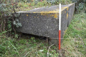
The overall form of this pillbox is rectangular in plan, with two square, enclosed fighting positions at each extent, joined by a central open bay which incorporates the entrance to the position and a concrete platform. Dimensions for the structure are 6.57m in length and 2.60m in width. Walls are 0.38m thick (bullet-proof standard). A measurement for the thickness of the roof was not possible at the time of survey but is estimated to be 0.25m thick. The structure is constructed from reinforced concrete with wooden shuttering used as a formwork. The central 'well' is often interpreted as a 'light anti-aircraft gun' position, as is indicated on the FW/3 23 drawing. The gun in question could have been a Bren Light Machine Gun, Lewis Light Machine Gun, or Hotchkiss Mk I* M1909 employed in the LAA role and operated by a crew of two. Observations made during this field survey indicated that the open position would have been relatively cramped, possibly limiting the operation of the LAA gun to an arc from the North-East to South-East. This position is also highly exposed, leaving the crew unprotected by the enclosure from the waist upwards. The practicalities of operating within this position need to be investigated further using experimental archaeology techniques. It was not possible to assess the central well of this example fully due to encroaching vegetation at the time of survey.
This pillbox faces to the North-East, with the entrance facing South-West, indicating that the expected avenue of approach for enemy troops was from the North-East. The pillbox’s embrasures can be found in the North-West, North-East, South-East and South-West faces, with two embrasures in the North-East and South-West faces and a single embrasure in the North-West and South-East faces (See images for locations).
The pillbox’s North-East and South-West facing embrasures are for Light Machine Guns (likely to be the Bren LMG) which would have also allowed the firing of rifles from within the pillbox. The embrasures sit flush with the outer surfaces of the structure, with no stepping to prevent projectiles from being funnelled into the structure. On first appearance, the lack of stepped embrasures seems logical as the embrasure is flush with the outer surface. However, measurements taken during survey reveal the sides of the embrasure taper inwards very slightly, creating a slight funnel into which incoming projectiles may be directed into the interior of the structure. Each embrasure also features a recess on the bottom surface. This would have been used to contain the folded bipod of the LMG. It is possible that a partially filled sandbag would be placed within the embrasures used to prevent damage to the bipod. This embrasure design is similar to that used in the lozenge shaped pillboxes found in Yorkshire. However, the embrasure employed in the lozenge shaped pillboxes allows the bipod to be deployed in the extended state. Whether this is evidence for the evolution of this embrasure design is unclear. This feature contrasts with the example to the south (Pillbox CITiZAN Ref: 26005), which lacks this recess. This could be an indicator of the evolution of the design and the identification for the need for the bipod recess during construction. These embrasures would have provided an approximate arc of fire of 60 degrees.
The North-East and South-West facing embrasures on this pillbox are a previously unidentified design with a specific function (see images). These embrasures have been extended considerably, creating an embrasure that extends to the North and East corners of the pillbox. These loopholes have clearly been cast during construction. This design of embrasure allows a considerably increased arc of fire, from the usual 60 degrees to 90 degrees in azimuth. The location of these loopholes in the pillbox suggest that a greater arc of fire was required to cover a larger area to the North-West and South-East in enfilade, allowing a greater area of the adjacent beach to be covered with effective fire. The embrasure also features a diagonally orientated rectangular recess, likely for the front leg of the Bren LMG tripod. The training pamphlet for the Bren LMG specifically states that when the gun deployed on a tripod for beach defence, that the gun should be set to fire at a range of 600 yards. At this range the cone of fire created when the gun is fired is relatively flat, passing no higher than head height; meaning that the gun can effectively defend a large area of flat beach with little need to adjust for range of target. This shows clearly that localised defence needs were identified prior to construction and the structure modified accordingly to accommodate the local requirements. Due to a lack of detail in the records of other examples of this pillbox, it is unclear whether this loophole design is unique to this structure or was employed in other pillboxes on the Lincolnshire coast.
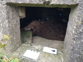
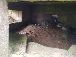
Access to the interior of the pillbox was not possible at time of survey but it was observed that the interior is heavily accreted with sand.
To consider the original landscape and defensive context of this pillbox, we must first understand that the surrounding landscape has changed considerably since the 1940s. Much of the surrounding landscape from the North to South is now established salt-marsh. In 1940, at the time of construction, the pillbox would have been sited on the coast edge, approximately 500m (measurement determined from period OS map) above the high water mark of an extensive beach. The current low water mark is similar to that of the 1940s. The salt-marsh that covers much of the surrounding landscape was created following major coastal flooding in 1953.
The surrounding landscape is relatively flat from the North to South, with good viewsheds across the flanks and forward arcs. From this location the pillbox was been sited to cover the flood defence bank to the rear of the position and the expanse of beach to the flanks and front of the pillbox.
Visibility and arcs of fire between the West to South arc would have been limited by vegetation and the flood bank. Fire could be brought to bear in enfilade to the North-West and Sout-West, with frontal fire possible on an arc from the North and South. The arcs of fire would have interlocked with adjacent pillboxes and would have been further bolstered by supporting trenches and weapon slits. The main vulnerable point would have been the beach itself, where the pillbox could bring fire to bear on any infantry landing on the beach. It is worth noting that infantry landed on the beach at very low tide would have been outside of the effective range of LMGs (if fired from the bipod) which were housed within the pillbox. Any infantry landing on the beach would be exposed with little available cover. Effective fire and manoeuvre would be required to supress the defending positions and advance across the beach towards the West.
Although the pillbox appears to be relatively isolated in the landscape, it is likely that it would be supported by trenches and weapon slits, as well as extensive barbed wire obstacles which have since been in-filled or removed. No such features were visible at the time of survey. Further field investigation and aerial photograph analysis is required to identify supporting positions.
Pillbox survives in Good condition (Fully or almost-fully intact and clear at time of survey).
Sources- Small Arms Training, Volume 1, Pamphlet No.4 Light Machine Gun (1939)
- Period
- Modern (1901 and later)
- Period comments
World War II
- The earliest date of the feature, as a year, if known
- 1940
- The latest date of the feature, as a year, if known
- 1943
- Monument Type - Broad
- PILLBOX (VARIANT)|PILLBOX|PILLBOX (TYPE FW3/23)
- Monument Type - Narrow
- Monument Description
- Evidence Type - Broad
- Evidence Type - Narrow
- Evidence Description
- Object Type - Broad
- Object Type - Narrow
- Object Description
- Height OD (m)
- How accessible is the feature?
- Not accessible, but visible from public path/road/adjacent land
- Accessibility comments
Other records:
- NRHE Number
- 1443430
- NT HBSMR Number
- Unknown
- HER Event Number
- Unknown
- External Link
- None
Over to you...
If you know there are errors in the original feature record above, you can edit the original record
If you would like to visit the feature and carry out a 'Feature Update Survey', you can prepare a 'Feature Update Survey' pack for this feature (in PDF format)
If you have completed a 'Feature Update Survey' for this feature, you can submit your 'Feature Update Survey'
If you want to use your smart phone to carry out the 'Feature Update Survey', you can download the CITiZAN smart app.
Feature Update Surveys
1 survey accepted and 0 pending.
Click on a survey to expand it.
- Date of survey
- 10th October, 2019
- Feature located?
- Yes
- State of the tide
- Low
- Proximity to coast edge
- More than 50m inland
- Coastal processes
- Is there a coastal defence?
- Other threats?
- Vegetation growth, Structural damage/decay
- If other, please specify
- Heritage Crime/illegal excavation or metal detecting
- How visible are the remains? ABOVE GROUND
- Highly visible (substantial remains)
- How visible are the remains in the face of the cliff, ridge or dune? IN SECTION
- Not applicable
- Do you know if the feature is?
- Is well known, Has local associations/history
- What actions (if any) would you recommend for this feature?
A detailed GIS interpretation of this structure, and other pillboxes in the area, will aid our understanding of this structure and the wider defensive landscape of this section of the Lincolnshire coast.
- Do you have any other comments?