ANTI TANK OBSTACLE|TANK TRAP
ANTI TANK OBSTACLE|TANK TRAP (22526)
- Easting
- 390809
- Northing
- 79120
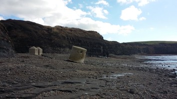
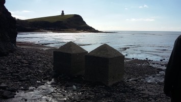
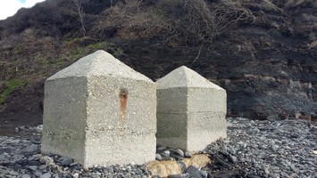
A World War II tank trap blocking the exit from the beach at Gaulter's Gap on Kimmeridge Beach, Kimmeridge Bay. The trap comprises two blocks constructed of conglomerate concrete in horizontal bands. Both are approximately 4 feet square and are spaced 31inches apart, and protrude 2 feet - 2.5 feet above the beach surface. Construction took place in 1940-41. A field visit in 1997 found the structures to be in a good condition.
- Period
- Modern (1901 and later)
- Period comments
Constructed 1940-41
- The earliest date of the feature, as a year, if known
- 1940
- The latest date of the feature, as a year, if known
- 1941
- Monument Type - Broad
- ANTI TANK OBSTACLE|TANK TRAP
- Monument Type - Narrow
- Monument Description
- Evidence Type - Broad
- Evidence Type - Narrow
- Evidence Description
- Object Type - Broad
- Object Type - Narrow
- Object Description
- Height OD (m)
- How accessible is the feature?
- Easily accessible - no restrictions, Accessible on foot (footpath)
- Accessibility comments
Other records:
- NRHE Number
- 1419123
- NT HBSMR Number
- Unknown
- HER Event Number
- Unknown
- External Link
- None
Over to you...
If you know there are errors in the original feature record above, you can edit the original record
If you would like to visit the feature and carry out a 'Feature Update Survey', you can prepare a 'Feature Update Survey' pack for this feature (in PDF format)
If you have completed a 'Feature Update Survey' for this feature, you can submit your 'Feature Update Survey'
If you want to use your smart phone to carry out the 'Feature Update Survey', you can download the CITiZAN smart app.
Feature Update Surveys
1 survey accepted and 0 pending.
Click on a survey to expand it.
- Date of survey
- 23rd February, 2016
- Feature located?
- Yes
- State of the tide
- Low
- Proximity to coast edge
- Coast edge
- Coastal processes
- Is there a coastal defence?
- No
- Other threats?
- Visitor erosion, Structural damage/decay
- If other, please specify
- How visible are the remains? ABOVE GROUND
- Highly visible (substantial remains)
- How visible are the remains in the face of the cliff, ridge or dune? IN SECTION
- Do you know if the feature is?
- Is well known, Is well visited, Has local associations/history
- What actions (if any) would you recommend for this feature?
The structure appears stable but would benefit from continued monitoring
- Do you have any other comments?
Photos
Anti tank defences Kimmeridge by LTidbury
Anti tank defences Kimmeridge by LTidbury