Crafting with CITiZAN on World Youth Day
12/08/2020 | Danielle Newman
In April 2020, as part of our COVID-19 digital engagement, Crafting with CITiZAN was born. Aimed at our younger volunteers, or those who are young at heart, these videos offer hands on activities demonstrating the impact of sea level change and coastal erosion on the coastline as well as exploring coastal industries and lives. For International Youth Day, we are highlighting two videos which were released this years as part of the Festival of British Archaeology.
International Youth Day is a UN initiative which seeks to encourage youth to engage with big issues on a local, national and global level. The 2020 theme “Youth Engagement for Global Action”,includes climate change, a subject at the core of the CITiZAN project. Check out our YouTube channel for many more videos!
Sea Level Change
Have you ever noticed that if you leave an ice cube out on the kitchen counter and come back to check on it in a while, you find a puddle? The same thing happens to ice in nature — if the temperature gets warm enough, the ice melts. This activity explores what happens to sea levels if the ice at the North Pole melts, or if the ice at the South Pole melts. Does melting ice at either cap contribute to a rise in sea levels? It is an especially important question for the millions of people who enjoy living along the coasts of the world and us at CITIZAN who study the heritage found there.
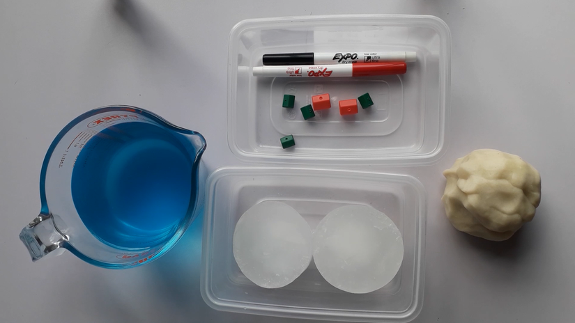
Supplies:
- Playdough or modelling clay
- Two small, clear containers (large takeaway size is perfect)
- Ice cubes
- Optional: blue food colouring & plastic models for a coastal village
Instructions:
- Put some play-dough or modelling clay into both of the the clear containers. We put ours along one short edge and possitioned the containers so both bits of "land" are next to each other.
- Add your ice so that it balances on top of the land mass of one of the containers. This container will be a model of the South Pole, with the mound representing the continent of Antarctica.
- Take the second, clear container add some ice cubes (or one big one if you have a silicon mould) to the "sea" portion. This container is a model of the North Pole, where the ice cubes represent the floating northern polar ice cap.
- Add you water to the container and immediately mark the water level on the side of the containers with a marker (we used a white board maker so it could wipe off). We also labelled them South and North Pole so it was easier to remember.
Bonus: We’ve added a few small plastic houses to the top of our land masses so it is easier to show the impact melting would have on coastal villages.
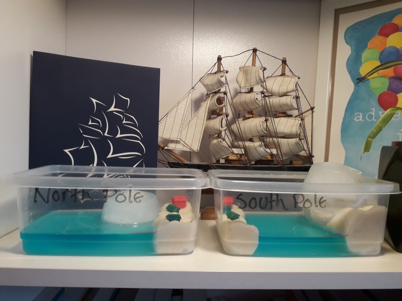
The ice on the North Pole is in the form of a floating polar ice cap, while the ice on the South Pole is mainly in the form of an ice sheet on top of the continent of Antarctica. As floating ice melts in water, the space the ice took up is replaced by water, so the water level in the North Pole model should not increase as the ice cubes melt. However, when an ice sheet on a landmass (such as in Antarctica or Greenland) melts, this does cause an increase in the water level. This is what you should have observed in the South Pole model, with the increase depending on the shape of the dough landmass and ice cubes. It is thought that if all of the ice on the poles melted, sea levels would increase by at least 200 feet, due entirely to the ice on the South Pole melting!
Coastal Erosion
Have you ever gone to a favourite beach and wondered why it’s smaller than you remember? Have you ever noticed what happens to the coastline when a big storm rolls through? Why does the beach look different? What you are noticing is the effect of coastal erosion. In this activity we are going to build our own beach to find out how this happens.
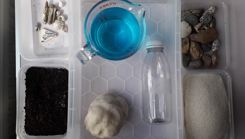
Supplies:
- Large container
- Sand (not kenetic)
- Empty plastic drink container
Optional: potting soil, play dough, rocks & shells…anything to make your shoreline more interesting!
Instructions:
The stones will represent those left by retreating glaciers after the last ice age. Potting soil can be added to represent the peat of old land surfaces. Playdough to stand in for clay, which is very fine rocks which often mixes with water to make mud or silt. And finally, sand as the modern seabed. You can include shells or anything else in different layers as markers for how much of your beach has eroded.
Assemble your beach (we recommend the order above) and then use the plastic bottle to make waves. What you are seeing at first is the loss of beach sand, usually from a combination of wind and water movement such as waves and currents. Sand is moved off the beach or shore by these things and is transferred to deeper water. This process makes beaches appear shorter and lower. If you move your plastic bottle quickly you can simulate the severe beach erosion after a strong storm because the wind and waves are so much more powerful.
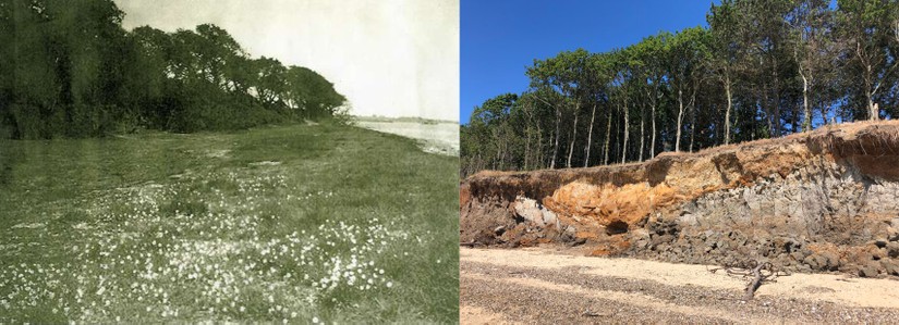
This is one of the main reasons why the CITiZAN archaeologists and volunteers are constantly monitoring sites, especially in winter after the big storms. Our coastline is changing so rapidly that every time we visit sites they are different. The picture above is of Cudmore Grove on Mersea island, the one on the left from 100 years ago and the one of the from a month ago. Imagine what it will look like 100 years from now?
If you have enjoyed making any of these crafts, please send us photos using our social media pages or by emailing Dani at dnewman@mola.org.uk. We love seeing them!