Dell Point lime kiln
Dell Point lime kiln (81865)
- Easting
- 423570
- Northing
- 629293
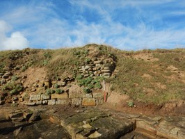
A group of four 'draw kilns' is depicted on the south-east side of Dell Point on a map of 1759. The map shows the estate of Thomas Wood, the landowner and entrepreneur who developed Beadnell's quarrying, lime-burning and other industries in the 18th century (Northumberland HER, PRN N24080). Site is now formed by a stone-built structure eroding out of the cliff face, thought to represent the remains of one of the limekilns.
- Period
- Post-Medieval (1540 - 1901)
- Period comments
- The earliest date of the feature, as a year, if known
- The latest date of the feature, as a year, if known
- Monument Type - Broad
- Industrial site
- Monument Type - Narrow
- Monument Description
- Evidence Type - Broad
- Structure
- Evidence Type - Narrow
- Ruined
- Evidence Description
- Man-made, roofless edifice or construction visible as substantial aboveground remains retaining evidence of architecture and materials, but which has been substantially destroyed.
- Object Type - Broad
- Object Type - Narrow
- Object Description
- Height OD (m)
- How accessible is the feature?
- Accessible on foot (no footpath)
- Accessibility comments
Access to the site is across the foreshore, caution needs to be observed. Site is located on edge of cliff, which may be unstable.
Other records:
- NRHE Number
- Unknown
- NT HBSMR Number
- Unknown
- HER Event Number
- PRN N24080
- External Link
- None
Over to you...
If you know there are errors in the original feature record above, you can edit the original record
If you would like to visit the feature and carry out a 'Feature Update Survey', you can prepare a 'Feature Update Survey' pack for this feature (in PDF format)
If you have completed a 'Feature Update Survey' for this feature, you can submit your 'Feature Update Survey'
If you want to use your smart phone to carry out the 'Feature Update Survey', you can download the CITiZAN smart app.
Feature Update Surveys
1 survey accepted and 0 pending.
Click on a survey to expand it.
- Date of survey
- 10th February, 2016
- Feature located?
- Yes
- State of the tide
- Low
- Proximity to coast edge
- Coast edge
- Coastal processes
- Active sea erosion
- Is there a coastal defence?
- Other threats?
- Vegetation growth
- If other, please specify
- How visible are the remains? ABOVE GROUND
- Limited visibility (partial remains)
- How visible are the remains in the face of the cliff, ridge or dune? IN SECTION
- Clearly visible in section
- Do you know if the feature is?
- Has local associations/history
- What actions (if any) would you recommend for this feature?
- Do you have any other comments?
Photos