Godwin Fort Coastal Battery
Godwin Fort Coastal Battery (22984)
- Easting
- 541780
- Northing
- 416059
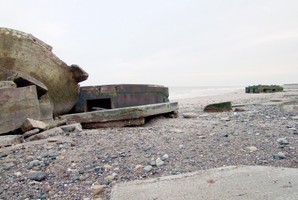
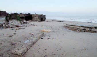
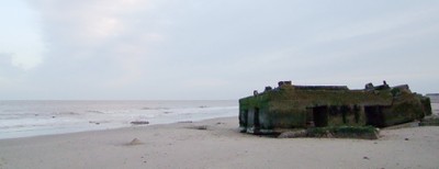
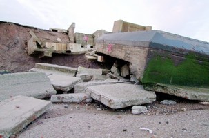
Godwin Fort was designed to protect the mouth of the Humber Estuary and to interact with the two forts built in the estuary at Bull Sands and Haile Sands. The fort opened in 1915 with two 9.2 inch guns. After the First World War the fort was kept in operation to train reservists, in 1940 the fort was re-equipped with a 4 inch mark IX gun on a naval mounting and a new pair of search lights were also added. Following the conclusion of the Second World War the fort was kept in operation until 1959 when it was put up for sale and eventually converted into a caravan park.
- Period
- Modern (1901 and later)
- Period comments
- The earliest date of the feature, as a year, if known
- 1915
- The latest date of the feature, as a year, if known
- 1959
- Monument Type - Broad
- COASTAL BATTERY
- Monument Type - Narrow
- Monument Description
- Evidence Type - Broad
- Structure
- Evidence Type - Narrow
- Evidence Description
- Object Type - Broad
- Object Type - Narrow
- Object Description
- Height OD (m)
- How accessible is the feature?
- Accessible on foot (no footpath)
- Accessibility comments
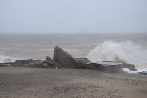
Coast edge eroding badly, no easy access to beach directly in the area.
Other records:
- NRHE Number
- 1421227
- NT HBSMR Number
- Unknown
- HER Event Number
- Unknown
- External Link
- None
Over to you...
If you know there are errors in the original feature record above, you can edit the original record
If you would like to visit the feature and carry out a 'Feature Update Survey', you can prepare a 'Feature Update Survey' pack for this feature (in PDF format)
If you have completed a 'Feature Update Survey' for this feature, you can submit your 'Feature Update Survey'
If you want to use your smart phone to carry out the 'Feature Update Survey', you can download the CITiZAN smart app.
Feature Update Surveys
2 surveys accepted and 0 pending.
Click on a survey to expand it.
- Date of survey
- 24th March, 2017
- Feature located?
- Yes
- State of the tide
- Mid
- Proximity to coast edge
- Intertidal zone
- Coastal processes
- Active sea erosion
- Is there a coastal defence?
- Other threats?
- Vegetation growth, Structural damage/decay, Other
- If other, please specify
- Graffitti
- How visible are the remains? ABOVE GROUND
- Highly visible (substantial remains)
- How visible are the remains in the face of the cliff, ridge or dune? IN SECTION
- Not applicable
- Do you know if the feature is?
- Is well known, Is well visited, Has local associations/history
- What actions (if any) would you recommend for this feature?
- Do you have any other comments?
Photos taken 05.12.09
- Date of survey
- 28th June, 2017
- Feature located?
- Yes
- State of the tide
- Low
- Proximity to coast edge
- Intertidal zone
- Coastal processes
- Active sea erosion
- Is there a coastal defence?
- No
- Other threats?
- Visitor erosion, Other
- If other, please specify
- Graffitti
- How visible are the remains? ABOVE GROUND
- Highly visible (substantial remains)
- How visible are the remains in the face of the cliff, ridge or dune? IN SECTION
- Limited visibility in section
- Do you know if the feature is?
- Is well known, Is well visited, Has local associations/history
- What actions (if any) would you recommend for this feature?
- Do you have any other comments?
Photos
Kilnsea Coastal Battery by tim3243
Kilnsea Coastal Battery by tim3243
Kilnsea Coastal Battery - with cliff edge by tim3243